

Weather: Heat, afternoon storms and strong meltemi will compose the scene of the next few days
Colder air masses descend towards the country from central and eastern Europe, bringing rains, locally strong storms, increased winds and a gradual decline in the mercury from Friday. Meteorologists recommend paying special attention to lightning, hail and strong gusts of wind
The weather scene changes from Friday onwards, as colder air masses from central and eastern Europe head towards the Balkans and gradually affect our country. The change will be accompanied by a noticeable drop in temperature, increased winds and the occurrence of rains and storms in several areas.
According to meteorologist Thodoris Kolydas in his post, atmospheric instability is expected to increase from Friday, resulting in rain and sporadic storms mainly in Macedonia, Thrace, Epirus, Thessaly, Central Greece and the mountainous parts of the Peloponnese.
The phenomena will not have the same intensity everywhere, however, in places they may be strong, with heavy rainfall, increased electrical activity, possible hail and strong gusts of wind.
At the same time, the temperature will begin to drop initially in the northern and central parts of the country, while later the colder air mass will expand further south. On Saturday, the drop in mercury is expected to become more noticeable in most continental areas.
At the same time, the north and northwest winds are strengthening, mainly in the Aegean, further contributing to the drop in temperature and the reduction of the feeling of discomfort from the heat.
The well-known meteorologist points out that this is not an organized wave of bad weather that will uniformly affect the entire country, but an episode of summer instability with local strong characteristics. For this reason, he draws attention mainly to the strong storms, lightning, possible hail and sudden increases in winds that may accompany the phenomena.
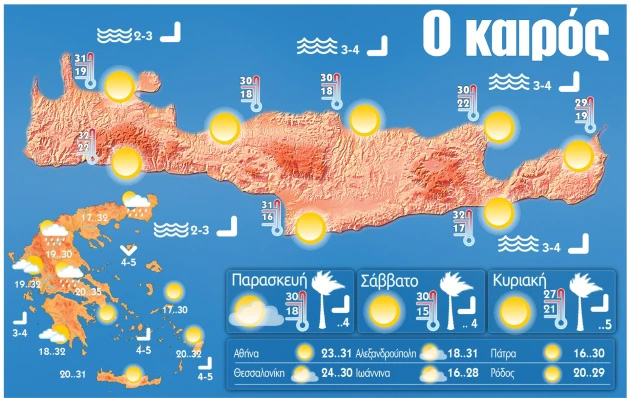
Forecast for Thursday 11.06.2026
Generally clear weather with temporary cloudiness in the mainland during the midday – afternoon hours, when local rains or showers will occur and mainly in the mountains isolated storms.
In western and central Macedonia, rain and showers will continue at night.
Winds will blow in the Ionian Sea from westerly directions 3 to 4 and in the Aegean Sea from northerly directions locally up to 6 Beaufort.
The temperature will increase slightly in the mainland and will reach 29 to 32 degrees in most areas of the country and locally in the eastern mainland 33 to 35 degrees Celsius.
In Crete
Generally clear weather is forecast for Crete tomorrow, Thursday. Winds will blow north-northwest 3 to 4 and locally up to 5 Beaufort. The temperature will range from 21 to 29, locally in Crete up to 30 to 31 degrees Celsius.
Attica
Weather: Generally clear with a few temporary clouds in the midday – afternoon hours.
Winds: Variable 2 to 4 Beaufort.
Temperature: From 20 to 32 to 33 degrees Celsius.
Thessaloniki
Weather: Generally clear with a few clouds, temporarily increased in the midday – afternoon hours, so mainly in the surrounding mountains there will be local rain or drizzle.
Winds: Variable 2 to 4 Beaufort.
Temperature: From 19 to 31 to 32 degrees Celsius.
Macedonia – Thrace
Weather: Generally clear with temporary clouds in the midday – afternoon hours and local rain or drizzle. Isolated storms are likely to occur in the mountainous areas of central and eastern Macedonia.
In western and central Macedonia, rain and showers will continue at night.
Winds: Variable 2 to 4 Beaufort.
Temperature: From 17 to 32 and locally 33 degrees Celsius. In western Macedonia 2 to 3 degrees lower.
Ionian Islands – Epirus – Western Sterea – Western Peloponnese
Weather: In the Ionian Islands generally clear. In the remaining areas generally clear with temporary clouds in the midday – afternoon hours, when local rains or showers will occur mainly in the mountainous areas, where isolated storms are also likely to occur.
Winds: Variable 2 to 3 and from noon westerly to 4 Beaufort.
Temperature: From 17 to 30 and in the mainland up to 32 degrees Celsius. In the interior of Epirus 2 to 3 degrees lower.
Thessaly – Eastern Sterea – Evia – Eastern Peloponnese
Weather: Generally clear with temporary clouds in the midday – afternoon hours in the mainland mountains, where local showers and possibly isolated storms will occur.
Winds: Variable 2 to 4 Beaufort.
Temperature: From 17 to 34 and locally 35 degrees Celsius.
Cyclades – Crete
Weather: Generally clear.
Winds: North northwest 3 to 4 and locally up to 5 Beaufort.
Temperature
Eastern Aegean Islands – Dodecanese
Weather: Generally clear.
Winds: From northerly directions 4 and locally 5 Beaufort.
Temperature: From 20 to 30 to 32 degrees Celsius.
Forecast for Friday 12.06.2026
Initially in Macedonia and gradually in the rest of the mainland and the northern Aegean cloudy with local rains and sporadic storms. Gradual improvement is expected from the afternoon in the west. In the rest of the country almost clear with temporary clouds.
Winds will blow in the south-west 3 to 5 and in the remaining areas from northerly directions 3 to 5 and gradually in the seas 6 and locally 7 Beaufort.
The temperature will drop slightly mainly in the central and northern parts and will reach 28 to 29 degrees in most areas of the country and locally in the eastern mainland 30 to 32 degrees Celsius.
Forecast for Saturday 13.06.2026
In the eastern mainland, Evia, Sporades, the islands of the northern Aegean and Crete, clouds with rain and mainly in the northwestern Aegean, sporadic storms. Gradual improvement from noon. In the remaining areas, few clouds that will gradually increase in the midday – afternoon hours in the mainland where local rains or showers will occur and possibly isolated storms in the mountains.
The winds will blow from northerly directions 4 to 6 and locally in the seas up to 7 Beaufort.
The temperature will drop slightly mainly in the east.
Forecast for Sunday 14.06.2026
In the northeast and southwestern Peloponnese, temporary clouds with the possibility of local rains. In the remaining areas, generally clear weather with few clouds temporarily increased in the midday – afternoon hours in the mainland and local rains or showers will occur in the west and northern mountains.
Winds will blow northwesterly 3 to 5 and in the Aegean locally up to 6 Beaufort. At noon in the Ionian Sea they will turn to westerly and weaken.
The temperature will increase slightly in the west and north.
Forecast for Monday 15.06.2026
Generally clear weather. A few clouds temporarily increasing in the midday – afternoon hours in the mainland where local rains or showers are likely to occur mainly in the mountains.
The winds are weak and only in the southeastern Aegean they will blow northwesterly 3 to 5 Beaufort.
The temperature will increase slightly further.